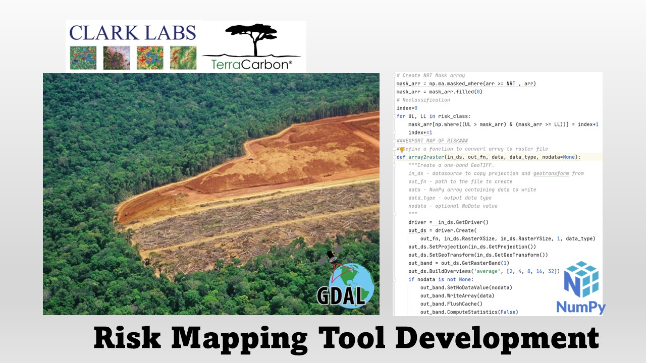
Developing Verra’s Jurisdictional and Nested REDD+ (JNR) Risk Mapping Tool
Develop Verra’s Jurisdictional and Nested REDD+ (JNR) Risk Mapping Tool using GDAL and NumPy with TerraCarbon LLC
Spatial Data Analyst / Engineer
I am a geospatial analyst/engineer with a great passion for learning state of the art technics to fix real-world problems. My expertise lies in integrating spatial analysis with data mining, spatial database, image classification with machine learning algorithms, and Web Mapping.
In the past few years, I worked on multiple projects as a GIS analyst and programmer on social inequality, wildfire, disaster management, and aquaculture. I am a hard-working and detail-oriented person. For me, GIS technics are so fascinating to help people tell a story, communicate with each other, and solve problems. Challenge comes with change. Let's begin!

Develop Verra’s Jurisdictional and Nested REDD+ (JNR) Risk Mapping Tool using GDAL and NumPy with TerraCarbon LLC
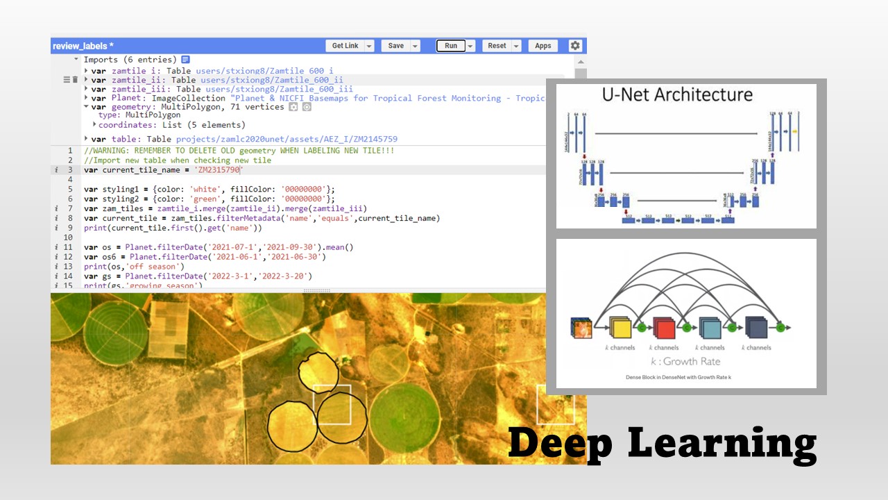
Created a Google Earth Engine(GEE) base labeling platform and workflow protocol. Wrote GEE API scripts to develop automation for label and imagery downloader and resample on Google Colab. Using PyTorch and scikit-learn to train and predict.
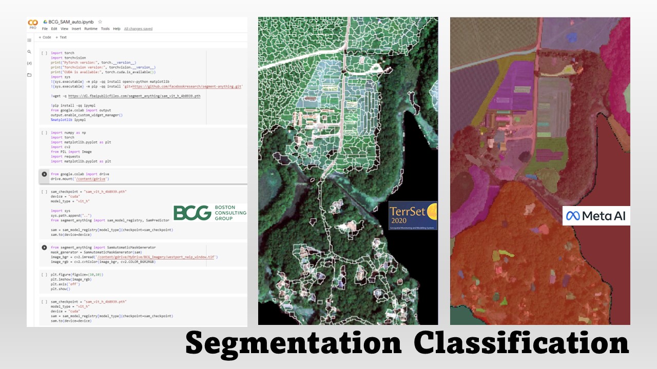
This project developed a comprehensive greenhouse map using 2021 Mass GIS Aerial Photo and NAIP Imagery collaborated with the Boston Consulting Group. It employed segmentation classification with Mahalanobis, SVM, and SAM algorithms to create the map, leveraging the mask generated from the Mass GIS 2016 Land Cover dataset.
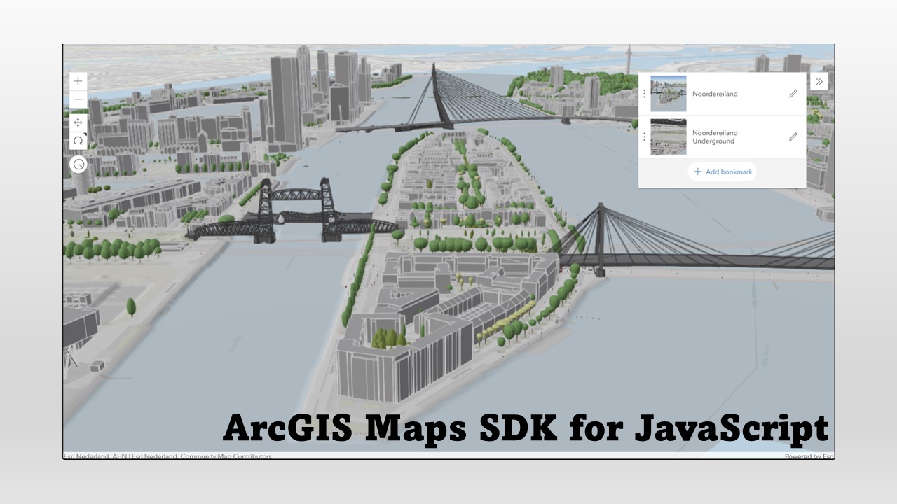
This section includes two projects written using the ArcGIS Maps SDK for JavaScript. The first project created 3D web scene with 3D building, infrastructure, and underground utility layers in ArcGIS Online and used ArcGIS Maps SDK for JavaScript to design an interactive web map, including bookmarks, mouse hover, and pop-ups information. The second project used 2017 States Education Smart Mapping FeatureSever to create an interactive 2D web map with user-selected fields and classification methods.
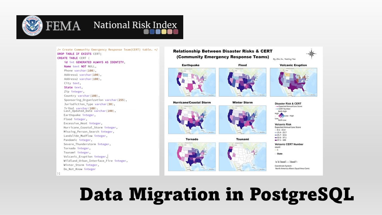
This project mined a series of FEMA Emergency Management and Disaster Datasets and designed database schema in pgAdmin. It provides crucial information needed by federal and state emergency responders and the public to evaluate resource and federal grant allocation of emergency response.
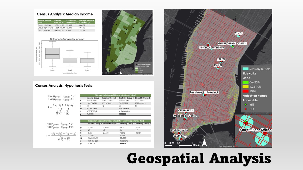
Explored the accessibility of pedestrian infrastructure for wheelchair users around ADA-compliant subway stations in New York City by using spatial analysis tools.
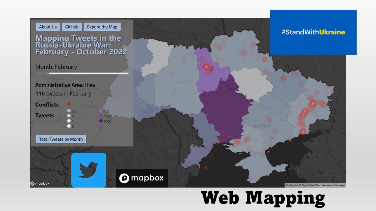
Visualized the relationship between the Ukraine conflict and social media activity using the Mapbox GL JS JavaScript library to design an interactive web map.
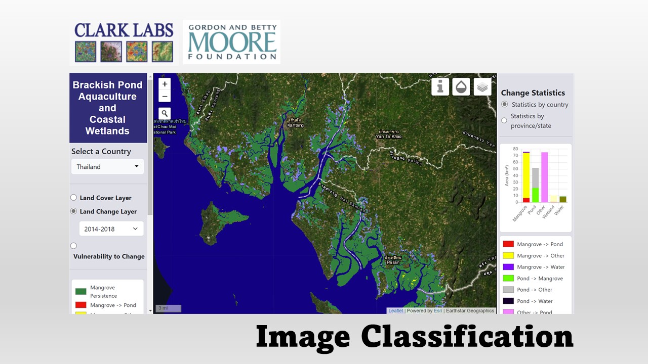
Work on Coastal Habitat Mapping project with the Gordon and Betty Moore Foundation. Create land-use map with Mangrove, Wetland, and Pond Aquaculture by using MLP and Mahalanobis supervised classifications in TerrSet Software.
Python, SQL, R, JavaScript, HTML5/CSS, C#
ESRI products (ArcGIS Pro, ArcMap, ArcGIS Online, ArcGIS StoryMaps, ArcGIS API for JavaScript), QGIS, GeoDa, and PostgreSQL/PostGIS databases
Google Earth Engine, GitHub, TerrSet, Visual Studio
Spatial Analysis, Cartography, Image Classification (Supervised, Unsupervised classification), Machine Learning (Random Forest, DenseNet, UNet)
• Develop Verra’s Jurisdictional and Nested REDD+ (JNR) Risk Mapping Tool using GDAL and NumPy with TerraCarbon LLC.
• Write Python scripts to speed up and reduce maintenance of automated classification procedures.
• Work on Coastal Habitat Mapping project with the Gordon and Betty Moore Foundation.
• Created land-use map with Mangrove, Wetland, and Pond Aquaculture by using MLP and Mahalanobis supervised classifications.
• Clean up Deep Learning Predicting results created by the CNN module.
• Crosstab cleaning for different temporal data at the country level.
• Helped Esri staff with registration, technical session monitoring, video and the
Esri Store.
• Learned to collaborate with people and communicate with
conference attendee with passion. Work hard, play hard.
• Interoperated satellite and aerial images to exam illegal land use, such as
illegal gravel mining.
• Appropriated public land use planning. Communicated with different bureau
of government by understanding what they needed, their budget under
land-use regulations.
• Assisted meetings within the Land Administration, and with GIS company to
rezone all land data and correct all out-of-date spatial data into new
functional zones.
• Analyzed land-use statistics and wrote annual reports.
• Led group counseling for social minority groups, including domestic violence
support group and mental illness recovery group in Taiwan and China.
• Hosted events and outings to help students connect with each other.
• Course: Python, Programming for GIS, Web Mapping, Geospatial Analysis With R, Spatial Database Develop, Advanced Raster, Advanced Vector
• GPA: 3.97
• Course: Urban Geography, Land Use Theory, Urban Planning
• GPA: 4.0
• Course: Remote Sensing, GIS, Statistics, Quantitative Geography, Intro to Computer Science, Calculus, Environmental Management, Geology, Topography, Physical Geography
• GPA: 3.7